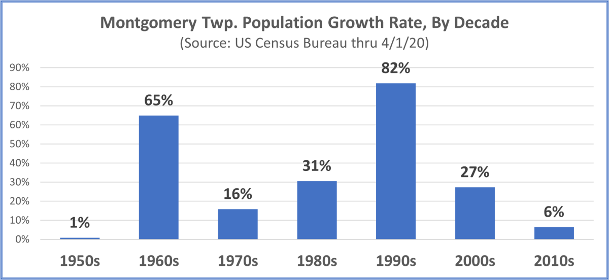
Population Growth
Montgomery Township is a historic agriculture community in central New Jersey that quickly grew into a suburban town. Major growth came in two spurts in the 1960s and 1990s, decades when population growth exceeded 60%. Since 2000, growth has moderated due to efforts by residents and community leaders to preserve the rural and agricultural character of the township. As of 2020, Montgomery’s population was 23,690, compared to 3,851 in 1960.
Quality of life, environmental protection, historic preservation, and public safety are some of the important values that are considered when making land use and zoning decisions.
Public participation in the planning process is encouraged when decisions are made about what kind of growth should occur, and where. The public has opportunities to advocate for open space and farmland preservation, redevelopment initiatives, changes to the Master Plan, and can weigh in during the approval process for projects initiated by private landowners.
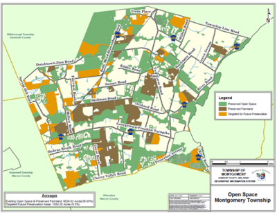
The most densely populated state in the nation, New Jersey has been at the forefront of open space and farmland preservation. Montgomery has long taken advantage of the New Jersey Green Acres open space grant program launched in 1961, and the New Jersey Farmland Preservation program since 1983.
Utilizing state programs and the dedicated municipal Open Space Tax, Montgomery has preserved over 8000 acres or 39% of township lands as open space or farmland. Almost 2,000 acres, or 9% of all land, have been identified for future preservation.
The Township’s efforts to preserve land have been aided by citizen participation through the Municipal Open Space Committee, the nonprofits Montgomery Friends of Open Space, D&R Greenway Land Trust, and the New Jersey Conservation Foundation. In addition, the township receives support from Somerset County programs, the Somerset County Agriculture Development Board, and the State of New Jersey through the NJDEP Green Acres program and the state Agriculture Development Committee.
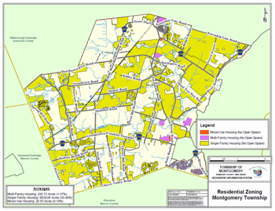
(Enlarge Residential Zones Map)
The main theme of Montgomery’s Master Plan is that we are a residential community with two "nodes" of mixed-use and commercial development along the Route 206 corridor. The steadfastness of Montgomery Township not to waiver from the Master Plan has prevented the evolution of a strip commercial pattern of development along Route 206, our main north-south thoroughfare.
Over 9,300 acres of Montgomery Township, about 45% of all land, is residential, and most of that is zoned for single-family housing. Residential tracts are located throughout the town, while zoning for mixed-use and multi-family houses is concentrated close to State Highway 206.
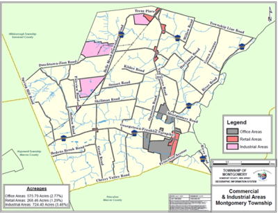
Areas zoned for offices are in the southern part of the township near Route 206 and represent 576 acres, or approximately 2.8% of township lands. Areas zoned for retail are 268 acres, or 1.3% of the township. While most retail areas are along Route 206, a retail node also exists in the historic Blawenburg village.
The final 3.48% of Montgomery Township lands are zoned as industrial. These lands are concentrated close to the CSX train line in the western part of town due to the importance of rail freight to the early industrial development.
Explore the Planning Department’s website for additional detail about the Master Plan, current projects, permit applications, and to contact the staff with questions.